Fushimi Inari Summit Loop: The Full Mountain Circuit Beyond the Torii Tunnels
Fushimi Inari is famous for its torii tunnels, and almost every visitor walks the same 800 m and turns around. The mountain behind the shrine, Mount Inari, has a genuine 8.2 km loop that climbs 230 m to a 233 m summit ringed with stone shrines, and past the Yotsutsuji junction the crowds thin sharply. It is an easy walk in terms of terrain — stone steps and graded paths throughout — but the constant stair climbing adds up over the course of the circuit.
- Distance
- 8.2km
- Elevation gain
- 230m
- Time
- 2.5h
- Grade
- Easyeasy
- Permit
- No permit required No permit. The shrine grounds are open 24 hours and free; the inner summit paths are unlit after dark.
- Season
- October to April; summer is humid and the lower shrines are packed before 9am
Geology and landscape
Underfoot, this is a mountain of broken stone rather than clean rock. Kyoto sits in a fault-bounded basin, and the hills that wall its eastern edge — the Higashiyama, with Inariyama at their southern end — are the uplifted, weathered remains of an old accretionary belt: layered sandstone, shale and chert that was scraped off the ocean floor, compressed, and lifted as the basin beside it sank. Walkers notice it in fragments. Stone steps cut into the slope expose dark, thinly bedded shale; gravel and chert rubble work loose on the steeper switchbacks; roots spiral over bands of harder rock where the softer layers have washed away. Rain does the rest, and the region's heavy summer downpours carve the gullies that the path keeps crossing. There are no crags and no bare summits here — only rounded ridges, deep shade and thin, iron-stained soil held in place by vegetation. It is a landscape shaped less by height than by water and time.
Flora, fauna and seasons
The lower slopes are a tangle of evergreen broadleaf forest — shii and kashi oaks among camphor and bamboo — kept cool and damp all year. Higher up, plantation cedar and cypress stand in straight dark rows, with moss and fern on the ground between them. Inariyama's foxes are stone; the living wildlife is quieter: tanuki and civet slip through at night, squirrels chatter in the canopy, and bush warblers, white-eyes and tits work the understory. From October to April, the trail is at its best — the air dries out, leaf cover thins, and the ridge paths open up. Late autumn brings maple colour to the Higashiyama slopes; camellias flower in the cold months; the first plum and cherry blossoms mark the turn to spring. Then comes the humidity. In summer the mountain turns green and heavy, insects rise, and the lower shrines fill with crowds long before nine in the morning. Wild boar root along the lower paths in autumn, and the shrine's stone foxes watch them pass.
History and culture
The mountain is a working shrine as much as a hill. Fushimi Inari Taisha traces its founding to the Hata, an immigrant clan from the mainland long associated with sericulture and the worship of Inari as a rice deity; tradition holds that the shrine was moved from the summit to the foot of the mountain by Kūkai, and that its great Romon gate was later donated by Toyotomi Hideyoshi. What you climb through is the accumulation of that devotion: thousands of torii, each an offering from a person or a business, along with countless small stone shrines, fox images and votive tablets set into the hillside. The circuit to Ichino-mine is an old pilgrimage route, walked as an act of gratitude and petition rather than as recreation. That continuity is the point. Every gate passed, every coin left, every name on a post belongs to someone who asked the mountain for something. At Ichino-mine, the summit shrine marks the spot where the deity is said to have descended.
Route description
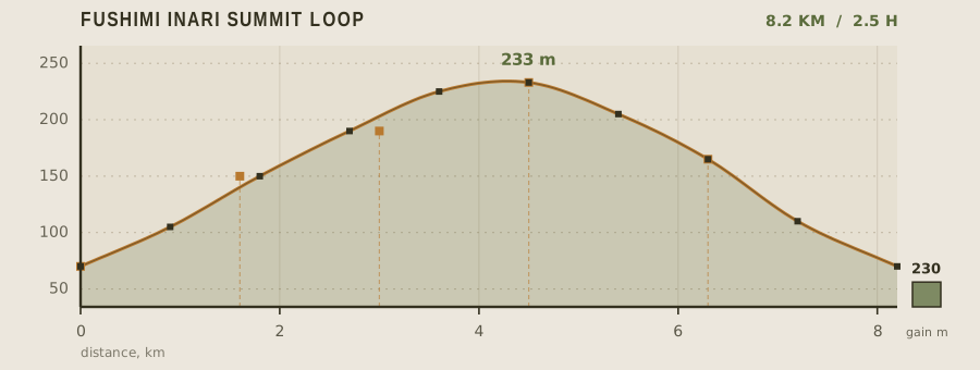
From the Romon gate, follow the Senbon Torii corridor uphill. The famous dense section ends around 400 m; the torii continue, but with wider spacing and fewer people. At Yotsutsuji junction, 1.6 km in, the corridor splits — the left fork is the inner loop and the logical direction for a full circuit. From there the path turns to stone steps and graded dirt through cedar and bamboo, reaching Mitsutsuji at 3 km and the Ichino-mine summit at 4.5 km. The descent follows the outer loop past Kumataka and several smaller sub-shrines, rejoining the main corridor at about 7.5 km and finishing back at the Romon. The full loop takes two to two and a half hours at a steady pace.
Water and resupply
Vending machines cluster at the shrine entrance and are the most reliable source, with prices barely above city rates. There is one shop at Mitsutsuji halfway up that sells drinks and ice cream in season but closes by late afternoon and shuts entirely in bad weather. There are no taps or springs on the mountain path, so carry a liter per person minimum — the humidity in Kyoto from June to September makes the climb sweatier than the elevation suggests.
Recorded water points
- Shrine entrance vending area0 km
Vending machines and a tea stall by the Romon; the last guaranteed water before the mountain.
- Mitsutsuji shop3 km
Bottled drinks and shaved ice; opening is weather dependent and stops by 4pm.
Bivouac and camping
Camping is not permitted anywhere on Mount Inari; the entire mountain is shrine land and the paths are open all night but not for overnight stays. Kyoto has ample hostel and hotel capacity within a 15 minute train ride, and the Keihan Main Line from Fushimi-Inari Station runs to Gion and downtown in 10 minutes. If you want to be on the mountain at dawn, the shrine is open 24 hours and a very early start from a Kyoto hotel is entirely practical.
Permit status
No permit. The shrine grounds are open 24 hours and free; the inner summit paths are unlit after dark.
Hazards and safety
The main risk is the stone steps, which are uneven, often damp, and worn smooth in the high-traffic lower section — descending is more dangerous than climbing, and most injuries happen on the way down. The inner loop paths are unlit, so finishing after dark requires a headlamp; the upper mountain has no lighting at all. In summer, heat and humidity are severe and the tree cover limits any breeze; start before 7am or after 4pm. Monkeys are occasionally seen but are not aggressive here. Winter brings occasional light snow on the upper paths, which makes the stone steps slick.
Read before you go
Distances, gain and water points here were recorded on the survey date. Confirm closures and current conditions with the managing agency, and leave your plan with someone staying behind.
Field conditions change. This survey is informational only and is not medical, navigational, or safety advice.