Lago di Braies Circuit: The Dolomites' Easiest Big-View Walk
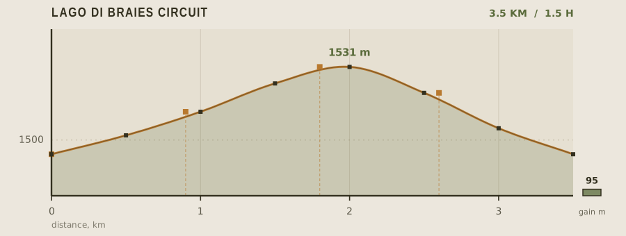
Pragser Wildsee, or Lago di Braies, sits at 1,494 m in a bowl under the Croda del Becco, and the 3.5 km path that circles it is the single most accessible way to see Dolomite limestone up close. It is a genuine alpine lake — deep green, cold year-round, fed by snowmelt — and the circuit gains only 95 m, all of it in one short rise on the west shore. The difficulty here is not the terrain but the crowds and the logistics of getting in.
- Distance
- 3.5km
- Elevation gain
- 95m
- Time
- 1.5h
- Grade
- Easyeasy
- Permit
- Permit required No hiking permit, but from mid-July to mid-September access by private car is restricted and you must book a timed shuttle or park at Monguelfo and ride in.
- Season
- Mid-June to early October; the road is closed to private cars in July and August
Geology and landscape
Pragser Wildsee sits in a hollow scooped by ice and then partly barred by its own falling walls. The surrounding rock is dolomite — a Triassic carbonate laid down in warm, shallow seas, later lifted, cracked and weathered into the pale towers that ring the basin. Underfoot on the circuit you meet that geology directly: flat boardwalk over the marshy delta at the south end, where fine sediment settles; gritty gravel and tree roots on the east shore; and, on the western side, a short climb over tumbled blocks and scree that have slid from the Croda del Becco above. The lake is the largest natural body of water in the Dolomites, held back at its northern end by a low barrier of debris rather than by a masonry dam. From the water's edge the Croda del Becco climbs steeply, its south face striped by the horizontal bedding planes of the original sea floor. Glacial polish and rounded, ice-smoothed boulders still read clearly beside the path.
Flora, fauna and seasons
The circuit stays in the subalpine belt, mostly below the treeline. Norway spruce and larch crowd the lower slopes, with mountain pine and dwarf shrubs on steeper ground; the south end is fringed by reeds, sedge and wet meadow where the Pragser Bach spreads out. Alpine flowers — gentians, monkshood, fireweed — appear on the higher verges as snow retreats. Chamois work the rock faces of the Croda del Becco and roe deer browse the forest edge; marmots whistle on open slopes above the lake, and golden eagles ride the thermals over the basin. On the water, mallards and grebes nest in the reeds, and a dipper may be seen where the inlet runs clear. The season given, mid-June to early October, brackets the whole arc: June brings snowmelt and high, cold, opaque water; high summer turns the lake a deep blue-green and fills the shore; by late September the larches yellow and the crowds thin, though the high ridges can already take fresh snow.
History and culture
Human use of the Prags valley is old, but the lakeside walk in its present form belongs to the Habsburg-era fashion for alpine summering. When this corner of the Dolomites was Austrian — the German name Pragser Wildsee long predates the Italian Lago di Braies, imposed after the First World War — Viennese visitors came by carriage road to a hotel at the water's edge, and a path was laid round the shore for exactly the kind of gentle circuit walked today. The small chapel at the south end marks the older, devotional strand of that traffic. The valley's people were German-speaking farming families, and the meadows around the lake were grazed and mown before tourism displaced that economy. Alpinists, meanwhile, used the lake as a base for the Croda del Becco, whose walls were among the Dolomite faces tackled in the early years of the sport. In the final days of the Second World War the hotel briefly held prominent prisoners moved from a concentration camp — a strange, sombre chapter for so serene a place.
Route description
Leave the hotel forecourt heading east on the wide gravel path along the north shore. The first kilometre is level and boardwalked in places, running beneath the vertical south face of the Croda del Becco — this is the photograph everyone comes for, and it is best before 9am when the wall is still in shade and the lake is glass. The path continues around the south end past a small chapel at 1.8 km, then climbs gently through larch on the west shore, the only real rise on the route. From the top of that rise the descent back to the hotel is 600 m of easy walking. The full circuit takes 90 minutes at a relaxed pace.
Water and resupply
The hotel and its kiosk are the only reliable source of potable water. Fill everything you need there, because the circuit has no fountains. The Pragser Bach enters the lake at about 1.4 km and runs cold and clear, but it drains grazing pasture upstream, so filter and chemically treat before drinking. If you continue north toward the Hochalpenkopf or the Grünwaldalm, carry at least two liters — those routes have no water at all.
Recorded water points
- Hotel Lago di Braies0 km
Taps, cafe, and a filled-bottle service at the kiosk. The only guaranteed potable point.
- Pragser Bach inflow1.4 km
Cold inflowing stream; agricultural runoff upstream means it should be filtered.
Bivouac and camping
Camping on the lakeshore is prohibited, and the car park is closed overnight. Legal campsites cluster in the Puster Valley around Monguelfo, Niederdorf, and Toblach, all 15 to 25 minutes away by car or bus, with tent pitches and rental cabins. The nearest mountain huts that take overnight guests are the Grünwaldalm and the Hochalpenkopf bivouac, both reached by long day trails from the lake rather than from the circuit itself.
Permit status
No hiking permit, but from mid-July to mid-September access by private car is restricted and you must book a timed shuttle or park at Monguelfo and ride in.
Hazards and safety
The water is glacier-fed and stays near 10°C even in August; immersion causes rapid cold shock and there is no lifeguard, so treat swimming as a serious risk and do not let children wade unsupervised. Sudden afternoon thunderstorms are the norm in July and August — the lake sits in a bowl with no shelter, and lightning on the Croda del Becco is frequent, so be off the open west shore by early afternoon. Bring a rain shell and grippy soles; the timber boardwalk is slick when wet. In early season, lingering snow on the west-shore rise can cover the trail and make the descent to the hotel icy.
Read before you go
Distances, gain and water points here were recorded on the survey date. Confirm closures and current conditions with the managing agency, and leave your plan with someone staying behind.
Field conditions change. This survey is informational only and is not medical, navigational, or safety advice.