Manoa Falls Trail: A Rainforest Waterfall Walk Above Honolulu
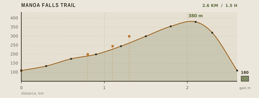
Manoa Falls is the shortest genuinely wild walk on Oahu. In 2.6 km round trip the trail climbs 180 m through a bamboo grove and a guava-and-fern understory to a 45 m ribbon of water pouring off the Ko'olau crest. Because the valley traps trade-wind cloud, the trail is damp almost every day of the year, and the footing — slick basalt, exposed roots, red clay — is the real difficulty, not the distance.
- Distance
- 2.6km
- Elevation gain
- 180m
- Time
- 1.5h
- Grade
- Easyeasy
- Permit
- No permit required No permit for day hiking. The trailhead gate closes at dusk and cars left after closing are ticketed.
- Season
- Year-round; the trail is wettest from November to March
Geology and landscape
Underfoot, almost everything is old volcano. The Ko'olau Range behind Honolulu is the eroded stump of a shield volcano whose windward flank was buried under stacked lava flows and ash. What a walker feels through boot soles — slick clay, red mud, greasy basalt — is that bedrock weathering fast under warm rain. The valley is a textbook amphitheatre: the headwall where the falls spill is a cliff of layered rock, cut back by Manoa Stream over an immense span of time. The 180 metres of climbing across 2.6 kilometres never turns brutal, but mud makes every rise feel earned. Higher up, roots and rounded cobbles break the surface, and the tread settles onto packed volcanic gravel. Trade winds stack cloud against the ridge most afternoons; the same rain that carved this gorge soaks your shirt as you walk. Look at the stream bed and you are reading the mountain's plumbing — the island's freshwater running seaward through a crack of its own making.
Flora, fauna and seasons
Rain builds this forest, and rain reorders it through the year. The lower stretch is a lowland rainforest thick with introduced species — strawberry guava, albizia, ginger, and the bamboo that gives the 0.8-kilometre corridor its name. Higher up, native trees gain ground: ohia with its grey trunks, kukui, and the sprawling uluhe fern that once covered these slopes before pigs and people rearranged them. Birds are mostly transplants too — white-rumped shama, Japanese white-eye, red-billed leiothrix — singing from the understory, with native honeycreepers holding on at higher elevations on the ridge. Mosquitoes are a constant. From November to March the valley is at its wettest: Manoa Stream at 1.1 kilometres runs brown and loud, the falls throw spray, and mud slows everyone to the same pace. In the drier months the stream shrinks to clear pools, the waterfall thins toward a ribbon, and the trail firms up, though rain can arrive in any month here. The shift can happen within a single morning: sun at the trailhead, drizzle beneath the canopy, honest rain at the falls.
History and culture
The valley has been farmed, prayed in and lived in for a very long time. In the Hawaiian ahupua'a system, Manoa was a rich agricultural valley — its stream fed irrigated terraces of taro, and the wet, warm floor supported fishponds closer to the sea. The name is usually rendered as something like 'thick' or 'vast,' fitting a valley that gathers cloud. Chiefs kept land here; later, immigrant farmers grew rice and taro in the same flooded patches while the valley filled with Honolulu's homes. The trailhead itself stands on the entrance road of a former tropical theme park whose gates have long since shut — the forest has swallowed the old attractions, leaving a parking area and a path. Nearby, a university botanical garden tends the valley's plant collections, and the falls draw crowds up from Waikiki. Water carried spiritual as well as practical weight; ditch, bathing pool and falls were understood as one connected body.
Route description
Start at the Paradise Park gate at the top of Manoa Road. The first 300 m is a wide, gravel-and-boardwalk grade suitable for strollers. At roughly 500 m the surface switches to unimproved dirt and the grade steepens to about 15 percent. You enter the bamboo corridor at 800 m; from there the trail is a single-track channel between root buttresses, usually muddy, with two short sets of steps cut into the clay. The stream crossing at 1.1 km is the only place you must choose a line — aim for the shallowest cobble bar on the upstream side. The last 200 m climbs a bamboo staircase to the viewing bowl. Return the same way; there is no loop and no exit over the ridge.
Water and resupply
Plan on a liter per person for the round trip and carry it in. The ranger spigot at the trailhead is treated municipal water. Manoa Stream is perennial, but it drains a populated valley and carries leptospirosis, so anything drawn from it needs a 0.2 micron filter plus chemical treatment. There are no shops, fountains, or vending machines between the gate and the falls.
Recorded water points
- Trailhead spigot0 km
Potable water at the ranger station. Treat as the only reliable fill point.
- Manoa Stream1.1 km
Perennial but carries leptospirosis risk. Filter to 0.2 micron and chemically treat if you must drink it.
Bivouac and camping
Camping is not permitted anywhere in the Manoa Falls trail corridor or at the falls. The nearest legal overnight is at the state campgrounds in the Ko'olau foothills, roughly a 20 minute drive away, and those require an online permit booked days ahead. Most visitors treat this as a half-day trip from Waikiki, about 20 minutes by car.
Permit status
No permit for day hiking. The trailhead gate closes at dusk and cars left after closing are ticketed.
Hazards and safety
Flash floods are the primary hazard: the valley is a steep, small watershed and the stream can rise within minutes of rain on the ridge, even when the trailhead is dry. Check the National Weather Service flash flood watch before you start and leave immediately if water turns brown and audible. Do not cross the barrier at the pool — rockfall from the cliff face is routine and there is no warning. Bring grippy shoes rather than sandals, and expect mosquitoes; repellent is worth the weight.
Read before you go
Distances, gain and water points here were recorded on the survey date. Confirm closures and current conditions with the managing agency, and leave your plan with someone staying behind.
Field conditions change. This survey is informational only and is not medical, navigational, or safety advice.