Maroon Bells Scenic Loop: A Gentle Walk Under Colorado's Most Photographed Peaks
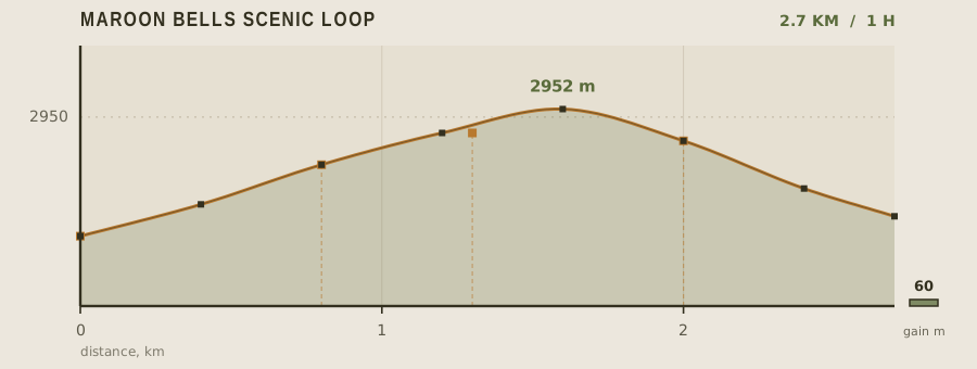
The Maroon Bells are two 4,200 m mudstone peaks that rise straight out of a glacial basin, and the 2.7 km scenic loop around Maroon Lake is the easiest way to see them. At 2,920 m the loop is nearly level, gaining only 60 m, but the altitude is the catch: this is a walk where people from sea level feel the elevation on a gentle gravel path. For anyone acclimatised, it is a pleasant hour with a view that rivals anything in the state.
- Distance
- 2.7km
- Elevation gain
- 60m
- Time
- 1h
- Grade
- Easyeasy
- Permit
- Permit required From mid-June to early October, private vehicles are barred from Maroon Creek Road between 8am and 5pm; you must reserve a shuttle seat or a limited parking pass online.
- Season
- Mid-June to early October; the access road closes in winter and the Maroon Bells shuttle runs in summer
Geology and landscape
The rock underfoot is the story here. Maroon Lake sits in a basin scooped and then dammed by ice, and the trail's first stretch crosses the low moraine that holds the water back — a jumble of cobbles and sand left behind when the last glaciers wasted away. Above it rise the Maroon Bells themselves: two peaks built of layered mudstone and siltstone, sediments laid down in ancient lowlands, then hardened, tilted and lifted as the Elk Mountains rose. Iron oxides stain those layers the deep rust-red that gives the peaks their name and that glows in photographs in a way the eye can barely believe. Because the rock is soft and closely fractured, frost and meltwater pry it apart faster than it can hold together, which is why the summits bristle with jagged, unstable edges rather than clean ridgelines. Walking the loop, you read the same process at eye level: shattered slabs on the path, pebbles of maroon shale, and the broad U-shaped trough of Maroon Creek below, a valley clearly carved by a river of ice and not by the stream now wandering through it.
Flora, fauna and seasons
Maroon Creek drains a valley that climbs from montane forest into subalpine country, and the loop samples both. Aspen clones — some of them enormous, connected underground by a single root system — flank the lower trail, their white trunks bright against dark conifers. Higher up and in wetter pockets, Engelmann spruce and subalpine fir take over, their spire shapes narrowing into the skyline. Willow thickets crowd the creek and the lake outlet; in July the meadows between them carry blue columbine, lupine and Indian paintbrush in dense, careless patches. Elk and mule deer graze the open ground at dawn and dusk, and the willows are good moose country. Black bears work the berry crop in late summer. Scolding gray jays and the chattering of red squirrels follow most walkers, and hummingbirds work the flowers. Timing matters. Mid-June still means snow banks, mud and high, cold runoff. July and August bring the wildflower peak. By late September and early October, the aspen turn and the whole valley goes gold against the maroon rock — the display that made this view famous — until snow closes the road for winter.
History and culture
These valleys are Ute country. Ute people moved through the Elk Mountains seasonally, hunting elk and gathering plants in the high basins, and Maroon Creek was part of that wide, mobile homeland rather than a fixed settlement. That relationship ended violently as settlers and mining money pushed into the mountains; the Utes were forced out of these valleys, and the land was reorganized for ranching, timber and, above Aspen, silver. The peaks themselves have their own human record. Climbers came early, and they learned what the rock does: the Bells shed holds, drop stones without warning, and have long carried the nickname the Deadly Bells among those who climb them. Later, the valley nearly went under a reservoir, a proposal that was fought and defeated and helped push the area toward the protection it now has — wilderness designation and scenic-area status that keep the road, the lake and the skyline much as the photographs promise. Today the trail is the rare place where a short, easy walk stands directly beneath mountains this famous.
Route description
The shuttle drops you at Maroon Lake, where the reflection view of the two peaks is 50 m from the stop. The loop heads west on a level gravel and boardwalk path through aspen groves, crossing Maroon Creek at 1.3 km on a footbridge above beaver ponds. The boardwalk section between 800 m and 1.6 km is genuinely accessible, wide enough for wheelchairs and strollers. At 2 km the scenic loop meets the junction for Crater Lake and Buckskin Pass — turn back here unless you have the gear and fitness for a serious alpine day. The return leg follows the lake's south shore and rejoins the trailhead shortly after.
Water and resupply
There is no potable water anywhere in the Maroon Bells basin — no taps, no fountains, nothing. Fill bottles at Aspen Highlands before boarding the shuttle, or in Aspen town. Maroon Creek and the lake outlet are cold and clear and are commonly filtered by backpackers, but the basin is one of the most heavily used in Colorado, so a 0.2 micron filter plus chemical treatment is the responsible minimum. At this elevation, dry air and rapid breathing mean you lose more fluid than the temperature suggests.
Recorded water points
- Maroon Lake outlet0.2 km
Cold stream leaving the lake. Filter and treat; heavy visitor use in the basin.
- Aspen Highlands base0 km
Before boarding the shuttle, fill bottles at the base area facilities.
Bivouac and camping
Overnight camping at Maroon Lake is not permitted; the area is day-use only and the last shuttle leaves mid-afternoon. Legal campsites are at the Silver Queen and Silver Bell campgrounds on Maroon Creek Road, which take tents and RVs and require reservation through the national reservation system, usually booked out months ahead for summer weekends. Dispersed camping is allowed on national forest land further down the valley with a free self-issued permit and a check on fire restrictions.
Permit status
From mid-June to early October, private vehicles are barred from Maroon Creek Road between 8am and 5pm; you must reserve a shuttle seat or a limited parking pass online.
Hazards and safety
Altitude is the main hazard. At 2,920 m, people arriving from low elevations commonly get headaches, nausea, and breathlessness, and the risk of worsening to high-altitude pulmonary or cerebral edema is real if you push on. Give yourself a day to acclimatise in Aspen before walking here, drink more than you think you need, and descend if symptoms worsen. Afternoon thunderstorms build fast over the Elk Mountains from July through August, and the open lake shore is fully exposed with no shelter — be off the loop by midday. The mudstone peaks themselves are notoriously loose and are not a beginner objective under any circumstances.
Read before you go
Distances, gain and water points here were recorded on the survey date. Confirm closures and current conditions with the managing agency, and leave your plan with someone staying behind.
Field conditions change. This survey is informational only and is not medical, navigational, or safety advice.