Mossy Cave Trail: Bryce Canyon's Shortest Introduction to Hoodoos
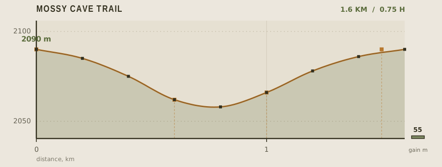
Most visitors meet Bryce Canyon from the rim, looking down. Mossy Cave Trail does the opposite: it starts below the rim in Water Canyon, at 2,090 m, and walks up into the amphitheatre so the hoodoos rise above you. At 1.6 km round trip with 55 m of gain it is the least demanding way to get close to the park's signature rock spires, and because it sits outside the main amphitheatre it draws a fraction of the traffic.
- Distance
- 1.6km
- Elevation gain
- 55m
- Time
- 0.75h
- Grade
- Easyeasy
- Permit
- Permit required No trail permit, but the park entrance fee applies and the shared-use path from the parking area requires a free self-issued day-use slip.
- Season
- April to November; the small waterfall is usually frozen from December to March
Geology and landscape
Every step of this 1.6-kilometre walk sits on the Claron Formation, a stack of Eocene lakebed sediments — limestone, siltstone, sandstone, scattered conglomerate — laid down when this corner of southern Utah held broad, shallow lakes. Uplift later raised those beds onto the Paunsaugunt Plateau, and water and frost have carved them ever since. What you feel underfoot tells the story: pale pink and orange limestone cobbles in the streambed, gritty sand on the flats, slick clay where the ditch has cut through softer layers. Water Canyon itself is a drainage notch bitten into the plateau's edge, and the modest 55 metres of climbing lift you from its floor toward the rim. Tropic Ditch Falls, at 0.6 km, is where a diversion canal spills over a lip of resistant rock, undercutting it into a small amphitheatre. Mossy Cave, further along, is an alcove hollowed from the cliff base by seeping groundwater rather than by a stream — a different erosion process, and the reason that rock stays damp while the rest of the canyon bakes. From the overlook, the hoodoos are the same Claron beds whittled into fins and pillars by freeze-thaw wedging.
Flora, fauna and seasons
Water has a way of rewriting the vegetation map here. Because Tropic Ditch leaks and spills year-round, the canyon floor supports a greener, damper community than the pinyon-juniper and ponderosa pine flats above it: sedges and rushes along the channel, bigtooth maple and gambel oak on the slopes, and — inside and around the dripping alcove at Mossy Cave — mosses, ferns and monkeyflowers clinging like a small hanging garden. Higher up, on the plateau rim, look for manzanita, mountain mahogany and the dark spires of Douglas fir. Quaking aspen shiver on the higher slopes, and in autumn they turn the hillsides gold. Wildlife follows the same water. Mule deer browse the willow and oakbrush at dawn; elk move through in the cooler months; coyotes and ravens are common year-round, and Steller's jays and chickadees patrol the conifers. Hummingbirds arrive with the summer flowers. From April to November the trail is a working walk — runoff in spring, monsoon thunderstorms in high summer, and crisp colour in the fall. From December to March, the small waterfall at Tropic Ditch usually freezes into a blue-white curtain, and the trail quiets down.
History and culture
The ditch that gives this walk its water is a piece of pioneer engineering. Settlers from the village of Tropic, on the plateau north of the park, needed irrigation for their fields and orchards, so in the late nineteenth century they dug a canal from the East Fork of the Sevier River, carrying it through the rim and down Water Canyon. It still runs today, still delivering water to the fields below the rim — a working irrigation canal inside a national park. The falls you pass are simply that canal spilling over the canyon lip. Bryce Canyon's hoodoos carry older meanings too. This is traditional Paiute country, and the Paiute tell of the Legend People — beings who were turned to stone, their painted faces frozen on the canyon walls. That story shapes how many visitors read the hoodoos at the overlook. The trail itself is a modest, modern addition to that long story: a short path off the highway, managed as part of the park, with a free self-issued day-use slip for the shared-use path from the parking area.
Route description
From the Highway 12 pull-off the path follows the Tropic Ditch, a hand-dug irrigation channel that has been carrying water to the town of Tropic since the 1890s. The grade is gentle and the surface is packed red dirt with a few stone steps. At 600 m the trail forks: go left for the waterfall, which pours 4 m over moss-covered limestone, and right for the cave. The cave branch continues another 400 m to a shallow seepage alcove, and a further 500 m up switchbacks to the hoodoo overlook. The whole system is short enough to walk both branches in under an hour.
Water and resupply
There is no potable water anywhere on the trail or at the trailhead. Bring at least a liter per person from Bryce Canyon City or the park visitor center. The Tropic Ditch is untreated irrigation water carrying agricultural sediment; it is not a drinking source under any circumstances. In summer the canyon has no shade after mid-morning, and the combination of 2,000 m elevation and dry air dehydrates people faster than the mileage suggests.
Recorded water points
- Trailhead0 km
No water. Bring everything from Bryce Canyon City, 10 minutes by car.
- Tropic Ditch0.6 km
Irrigation water, turbid and untreated. Do not drink it.
Bivouac and camping
Dispersed camping is not allowed on this parcel; it falls under the park's day-use rules. The two park campgrounds, North and Sunset, are 15 minutes away and fill early in season, so reserve online months ahead. National forest land outside the park boundary — along the Rim Road and the Paunsaugunt Plateau — permits dispersed camping with no fee, but requires packing out all waste and checking current fire restrictions.
Permit status
No trail permit, but the park entrance fee applies and the shared-use path from the parking area requires a free self-issued day-use slip.
Hazards and safety
The hoodoos are made of soft Claron limestone and the slopes beneath them are loose scree; stay on the marked path, because the crust looks solid and collapses. Afternoon thunderstorms are frequent from July through September and Water Canyon is a flash-flood chute — if the ditch turns muddy or you hear a roar, get to high ground immediately. At 2,090 m the UV is intense and the air is dry, so sun protection and electrolytes matter more than on a comparable low-elevation walk. Winter brings ice on the steps and the waterfall freezes solid, which makes the stone treads treacherous without traction devices.
Read before you go
Distances, gain and water points here were recorded on the survey date. Confirm closures and current conditions with the managing agency, and leave your plan with someone staying behind.
Field conditions change. This survey is informational only and is not medical, navigational, or safety advice.