Prince Henry Cliff Walk: Katoomba to Leura Along the Jamison Escarpment
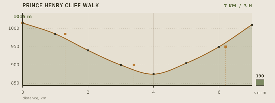
The Prince Henry Cliff Walk threads 7 km of the Jamison Valley escarpment between Echo Point and Gordon Falls, staying within a few metres of a 200 m drop for most of its length. It is one of the most rewarding short walks in the Blue Mountains because it never descends into the valley — you keep the view the whole way — and the 190 m of elevation change is spread so thinly that it barely registers.
- Distance
- 7km
- Elevation gain
- 190m
- Time
- 3h
- Grade
- Easyeasy
- Permit
- No permit required No permit for walking. The Scenic World cableway and railway are ticketed separately if you use them to shortcut the route.
- Season
- September to May; winter mornings bring fog in the valley and slick boardwalks
Geology and landscape
Underfoot, almost everywhere, is sandstone. The rock beneath the Prince Henry Cliff Walk is Triassic sedimentary layers — sand and gravel laid down in river systems and lakes, compacted and then lifted as part of the great plateau that now forms the Blue Mountains. This is not a mountain range in the tectonic sense; it is an eroded plateau, and the Jamison Valley below Echo Point is what remains after rivers and weather worked their way down along ancient joint lines. The cliff edge you follow is a retreating one. Blocks spall away along vertical fractures, leaving the sheer faces, overhangs and undercut ledges that give the track its drama. The Three Sisters, those three pinnacles near Echo Point, are simply the last remnants of a spur that erosion has cut back on three sides. Walkers step over ironstone bands, cross sandy, gravelly soils, and pass slabs where honeycomb weathering pits the surface. Across the valley, Mount Solitary sits as a plateau fragment — same rock, same story, isolated.
Flora, fauna and seasons
Cliff-top vegetation here is dry sclerophyll forest: eucalypts with stringybark and peppermint textures, banksias, hakeas and grass trees crowding the rim, their roots gripping the shallow soils. Step to the edge and the plant list flips entirely. In the shaded gullies below, coachwood, sassafras and tree ferns form warm temperate rainforest, and hanging swamps — soaks fed by seepage along the cliff line — hold button grass and sundews on ledges where you would not expect anything to grow. Wildlife follows the same vertical pattern. Superb lyrebirds scratch through leaf litter near Echo Point; crimson rosellas and king parrots move noisily through the canopy; white-throated treecreepers work the trunks. Swamp wallabies browse the regrowth, echidnas poke about the trackside, and in the warmer months brown and red-bellied black snakes sun on the rock slabs. September to May is the generous stretch: waratahs, boronias and epacris flower in spring, and the escarpment dries to a pale gold over summer. Winter mornings reverse everything. Fog fills the Jamison Valley, the boardwalks glaze with moisture and frost, and the cliffs vanish.
History and culture
Long before any track existed, this escarpment was Gundungurra and Dharug country, and the Jamison Valley — with its waterholes, camps and routes over the ridges — carried people through the landscape rather than simply beneath it. The Three Sisters are entangled with a story told across the region and retold endlessly to visitors at Echo Point, of sisters turned to stone. European settlement reached the upper mountains in the nineteenth century, and the railway turned Katoomba into a resort town. Guesthouses multiplied, entrepreneurs cut steps and paths into the cliffs to reach the waterfalls and viewpoints, and the Scenic Railway began life as a working tramway serving the shale and coal mines on the valley floor before it became a tourist ride. The Six Foot Track, the bridle path pushed through to Jenolan, crossed country near here. In the twentieth century, conservationists campaigned to protect these cliff lines, and the walking routes — including this one, which carries a royal name from that high-imperial era — became the backbone of what is now a national park.
Route description
Start at Echo Point, where the Three Sisters stand directly below the lookout. The path runs west along the cliff edge, crossing Katoomba Cascades at 1.3 km on a broad boardwalk with handrails. From there it narrows and begins to undulate, passing beneath the escarpment through eucalypt and coachwood. The lowest point comes at the Cliff View junction around 3.4 km, right under the vertical sandstone wall — stop here and look up, because the scale is invisible from the lookouts. The track then climbs steadily through Leura Forest edge country, emerging at Sublime Point Road at 6.2 km and finishing at Gordon Falls in Leura. Buses run back to Katoomba from Leura Mall every 30 minutes.
Water and resupply
Echo Point has the only taps on the route, so carry at least a liter and a half per person. Leura at the far end offers full resupply. The cascades and forest creeks in the Jamison Valley are not treated drinking water and the plateau catchment is shared with urban runoff, so filter and treat if you intend to use them. On hot summer days the sandstone radiates heat and the exposed sections between the tree cover push fluid loss much higher than the 7 km distance suggests.
Recorded water points
- Echo Point visitor centre0 km
Public taps and a cafe. Fill up before you leave the lookout.
- Leura town7 km
Full resupply at the end of the walk: supermarkets, bakeries, and public toilets.
Bivouac and camping
There is no camping on the Prince Henry Cliff Walk and none in the Jamison Valley below it — the valley is a declared wilderness area with no camping permitted on the valley floor. The nearest legal sites are the Blackheath and Katoomba caravan parks on the plateau, both a short drive from Echo Point, plus the campsites at Mount Wilson and Megalong Valley. Most walkers do this as a half day and stay in Katoomba or Leura, both of which have hostels and guesthouses.
Permit status
No permit for walking. The Scenic World cableway and railway are ticketed separately if you use them to shortcut the route.
Hazards and safety
The escarpment edge is unfenced in many places, and the sandstone is brittle — people fall every year from the cliff line between Echo Point and Leura. Stay behind the obvious worn path and never step onto exposed rock slabs near the lip to get a photograph. The boardwalks are timber and stay wet and slick for days after rain. Bushfire is the other serious risk: the Blue Mountains has a long fire history, and on Total Fire Ban days the escarpment tracks are closed, so check the Rural Fire Service fire danger rating before you leave. Snakes are common on the warm sections in spring.
Read before you go
Distances, gain and water points here were recorded on the survey date. Confirm closures and current conditions with the managing agency, and leave your plan with someone staying behind.
Field conditions change. This survey is informational only and is not medical, navigational, or safety advice.