Seven Sisters Cliff Path: Walking the Chalk Edge of the Sussex Coast
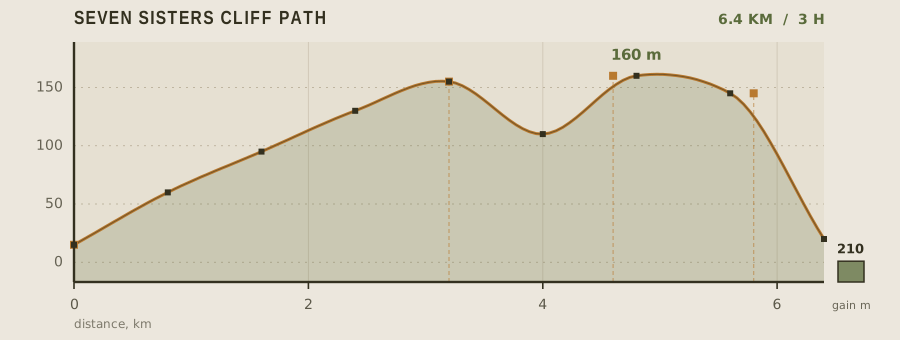
The Seven Sisters are seven consecutive chalk summits between Seaford and Eastbourne, and the clifftop path that crosses them is the most walked coastal route in southern England. It is short — 6.4 km one way with 210 m of cumulative climbing — but it is undulating rather than flat, and the downs-and-ups arrive in quick succession, which makes the effort feel larger than the numbers suggest.
- Distance
- 6.4km
- Elevation gain
- 210m
- Time
- 3h
- Grade
- Easyeasy
- Permit
- No permit required Open access land and National Trust paths; no permit. Some sections close temporarily for cliff erosion.
- Season
- April to October; chalk grassland flowers peak in June and July
Geology and landscape
Every step of this path lands on chalk — the compacted remains of microscopic marine plankton that settled in a warm, shallow sea during the Cretaceous period, when this coast lay far south of where it sits today. The white rock lies in gentle beds that tilt imperceptibly seaward, which is why the cliffs here fall away in long, clean faces rather than jagged crags. Flint, in dark knobbly bands, works loose from those beds and litters the turf: you will see it underfoot and stacked into the walls of old field boundaries. The Seven Sisters themselves are the product of wave attack on that soft rock. Each white headland is separated from the next by a dry valley — a coombe cut by meltwater in colder eras and now left high above the sea, since the chalk here is porous and the streams have long since drained underground. Inland, those same valleys show as deep green creases in the downland. Where the sea has bitten furthest, as at Cuckmere Haven, the river has been pushed into looping meanders, and at low tide a wave-cut platform of chalk shows beneath the cliffs.
Flora, fauna and seasons
Chalk grassland is the defining habitat, and it is a man-made one: centuries of close sheep grazing have cropped the turf short and stopped scrub from swamping it, letting an extraordinary density of small plants hold on. Cushions of sheep's fescue and quaking grass, yellow bird's-foot trefoil, salad burnet, wild thyme and marjoram all grow within arm's reach of the path, and the near-white blossoms of dropwort and the pink spikes of round-headed rampion — the county flower — appear through the summer. Orchids, pyramidal and bee among them, push up where the grazing is thinnest. June and July are the peak: the turf is at its most flowery and the downland butterflies are on the wing, chalkhill blues and Adonis blues among them. Spring brings early, wind-bitten flowers and passage wheatears moving through; by autumn the colour has drained to hawkweed and the first sea asters below the cliff edge, with hawthorn berries reddening in the scrub. Winter strips the down to bare, wind-scoured turf, and the cliffs belong again to fulmars, kittiwakes and the resident peregrines.
History and culture
People have used this edge for a very long time. Seaford Head carries an Iron Age hillfort, its ramparts still readable in the turf, and the same headland holds burial mounds from later centuries — reminders that the chalk downland was farmed and defended long before any path was marked. The short, springy turf itself is a historic artefact: it survives because generations of shepherds ran sheep across it, and the close grazing that made the grassland is the same practice that keeps it open today. The coast below had a sharper reputation. The Cuckmere valley was smuggling country, and the neat row of coastguard cottages above the meanders was built so that men could watch the river mouth for contraband coming ashore. In the 1800s the whole stretch was fortified against invasion, and squat Martello towers still stand along the low ground. Belle Tout, the clifftop lighthouse, belongs to that maritime story; as the cliff retreated beneath it, the building was hauled back from the edge at the end of the twentieth century, a piece of engineering that reads almost as a commentary on this whole eroding coast.
Route description
From Seaford Head the path trends east, contouring above the Cuckmere Valley before dropping steeply to the river at 3.2 km. Cross the meanders on the footbridge and follow the tide-worn track up onto the first of the Sisters. From there the route is a series of short climbs and descents along the cliff edge, each summit giving a slightly different angle on the previous one. Birling Gap, at 4.6 km, is the only built-up interruption; the path passes behind the cafe and continues over the last two summits to Belle Tout and the descent into Eastbourne. Buses return to Seaford along the coast road if you do not want to walk back.
Water and resupply
There is no water on the cliff tops — none. Carry at least a liter per person and top up at Seaford seafront or Birling Gap cafe, which is the only commercial stop on the route and closes in winter. The Cuckmere estuary is tidal and brackish; do not treat it as a source. Pubs in Eastbourne and the village of Litlington, a short detour inland, are the other options.
Recorded water points
- Seaford promenade0 km
Cafe taps and public toilets at the seafront before you climb.
- Birling Gap cafe4.6 km
Bottled water and hot drinks; seasonal opening, closed in midwinter.
Bivouac and camping
Wild camping is not legal on the Seven Sisters. The nearest official sites are farm campsites in the Cuckmere Valley and on the South Downs escarpment, both within a 30 minute walk of the path, and they take tents without booking outside of bank holidays. Eastbourne and Seaford both have hostel and hotel beds. Most people walk this as a single day and sleep in town either side.
Permit status
Open access land and National Trust paths; no permit. Some sections close temporarily for cliff erosion.
Hazards and safety
The chalk is soft and the edge is genuinely unstable. Stay at least a few metres back from the cliff lip; undercut blocks and overhanging turf fail without warning and there is no fence along long stretches. Do not attempt the descent to the shore except at the marked stairs at Birling Gap and Cuckmere — several people each year are injured scrambling on loose chalk. The cliff tops are fully exposed to wind and rain with no shelter, so a shell layer is mandatory even on a forecast-good day. In wet weather, the clay over chalk becomes extremely slippery on the descents.
Read before you go
Distances, gain and water points here were recorded on the survey date. Confirm closures and current conditions with the managing agency, and leave your plan with someone staying behind.
Field conditions change. This survey is informational only and is not medical, navigational, or safety advice.