Torc Mountain: Killarney's Best Effort-to-View Ratio
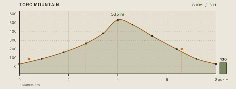
Torc is the smallest of the Killarney mountains at 535 m, and that is exactly its appeal. In 8 km round trip and 430 m of ascent it delivers the same panorama of the Lakes of Killarney that bigger neighbours take twice the effort to earn, and it does so on a route that is part tourist path, part open hillside. The final 600 m to the summit is on bare rock slab with no cover, which is where the day's weather decides the difficulty.
- Distance
- 8km
- Elevation gain
- 430m
- Time
- 3h
- Grade
- Moderatemoderate
- Permit
- No permit required No permit. Most of the route crosses Killarney National Park; the upper section is open mountain with no restrictions.
- Season
- May to September; the summit slab is exposed and the descent is unpleasant in high wind
Geology and landscape
Underfoot on Torc is almost all Old Red Sandstone, the pinkish-grey rock that gives Kerry its characteristic hue. It began as sand and gravel washed off the Caledonian mountains to the north during the Devonian period, when this corner of the world lay in a semi-arid continental basin. Later earth movements — the Variscan folding that raised the great ridges of the southwest — tilted and crumpled those beds into the long east-west grain you can read in every skyline above Killarney. The Ice Age did the rest. Ice scoured the valleys, deepened them, and left the lakes sitting in over-deepened troughs. It also cut the step that the Owreagh River now falls over at Torc Waterfall, tumbling off a band of harder rock into the wooded hollow below. Higher up, the ridge turns bare; peat, thin soil and broken slabs replace the forest floor. Near the summit, the rock is polished and rounded in places, a smoothness that betrays the passage of ice rather than any trick of weathering.
Flora, fauna and seasons
From the car park the trail begins in dense woodland, and those first kilometres are the richest botanically. Killarney holds Ireland's largest surviving tract of native oak wood — sessile oak, with holly, birch and rowan — and its oceanic dampness makes the place a nursery for mosses, liverworts and ferns that elsewhere in Europe are scarce. Above the Old Kenmare Road crossing the trees give way to heath and blanket bog: heather, bilberry, purple moor-grass, the ground spongy and dark. Red deer, long regarded as the last remnant of Ireland's native herd, move between the woods and the open hillsides; ravens and peregrines work the crags. Spring and early summer are when the oak canopy closes and the falls run strongest after rain. By late summer the heather is in flower and the upper slopes carry their colour. September keeps the light soft and the ground drier. Wind, not rain, ends the season here: the bare summit slab is exposed, and the descent loses its charm in a gale.
History and culture
The name Torc is Irish for a boar, and the waterfall has carried legends of that animal — and of human misfortune there — for centuries. Such stories belong to the older, Gaelic layer of Killarney's history, when these valleys were a route-way rather than a tourist attraction. The Old Kenmare Road the trail meets is the surviving trace of that older traffic: a hard mountain road linking the two towns across the hills, used by people and pack animals long before coaches and jaunting cars arrived. In the nineteenth century the lakes and falls became a set-piece of the Victorian grand tour, and the Muckross estate at the foot of the mountain drew fashionable visitors to its grounds. That estate was later gifted to the nation and became the heart of Ireland's first national park, which is why so much of the route is protected ground. Walking it now, you are on a road worn by travellers, then tourists, in turn.
Route description
From the Torc car park, follow the well-made path 400 m to the waterfall. The mountain route turns left at the viewing platform and climbs a long flight of timber-and-stone steps through oak and holly — this is the steepest sustained section of the day and it lasts about a kilometre. Above the trees the path becomes a wet, eroded track across open hillside, which is where proper boots start to matter. At 2.7 km you cross the Old Kenmare Road, a useful decision point. From there the route climbs diagonally across the north shoulder and reaches the summit slab at 4 km. Descend by the same shoulder to the old road, then follow the railway viaduct path back down, which returns you to the car park by a slightly different and quieter line at 8 km.
Water and resupply
There is no water on the mountain and no taps above the car park. The toilets at the trailhead are the only reliable fill point, so carry a litre and a half per person in summer. The Owreagh River below the falls runs cold and clear, but it drains a grazed and forestry-planted hillside, so it needs a filter plus chemical treatment. Rain is the norm in Kerry — the mountain collects weather from the Atlantic with nothing to stop it — so a shell layer and a dry bag for your phone are worth more than an extra snack.
Recorded water points
- Torc Waterfall car park0 km
Toilets with drinking water taps; the only reliable fill on the route.
- Owreagh River0.4 km
Fast clear water below the falls, but it drains grazed hillside; filter and treat.
Bivouac and camping
Wild camping in Killarney National Park is restricted and is not permitted on the Torc massif or around the waterfall. The nearest official options are the caravan and camping parks in Killarney town, about 10 minutes away, and the hostel and guesthouse beds in the town itself. There are two bothies and a small number of permitted wild-camping zones elsewhere in the park, but these require checking with the National Parks and Wildlife Service in advance and are mostly oriented to the Black Valley and Mangerton side.
Permit status
No permit. Most of the route crosses Killarney National Park; the upper section is open mountain with no restrictions.
Hazards and safety
The summit slab is fully exposed. Wind on Torc is amplified by the funnel between the lakes and the MacGillycuddy's Reeks, and people are regularly blown off balance on the top 200 m — in gusts above 60 km/h, turn around below the summit rather than pressing on. The descent on wet rock is the other risk; the slab is polished in the middle where everyone walks, and the eroded hillside track is muddy and slippery. Navigation is straightforward in clear weather but the upper mountain is featureless in cloud, so carry a map and compass or a charged phone with offline maps. Kerry weather changes on a scale of 20 minutes.
Read before you go
Distances, gain and water points here were recorded on the survey date. Confirm closures and current conditions with the managing agency, and leave your plan with someone staying behind.
Field conditions change. This survey is informational only and is not medical, navigational, or safety advice.